Shanghai, China

Local News | Weather | Airports
(All External Links)


Maps of Shanghai

上海交通地图 Map of Shanghai

Click to see full sized-map

JohoMaps! 2005


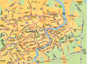
City Map of Shanghai
  Date:   Jun, 2007 (3rd Ed)
Map format:   jpeg
Dimension:   972 x 713 pixels (939 kb)
Copyright holder:   Johomaps!
Conditions of using this map:   Unlimited educational use, free download.  Free web posting with web link to www.johomaps.com
Computer Specifics:   Prepared using Adobe Illustrator


上海地铁图 Shanghai Metro Map

Click to see full sized-map

JohoMaps! 2005-07


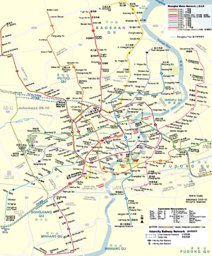
Metro Map of Shanghai
  Date:   Dec, 2007 (7th Ed)
Map format:   jpeg
Dimension:   856 x 1100 pixels (665 kb)
Copyright holder:   Johomaps!
Conditions of using this map:   All rights reserved.  Contact for permission
Computer Specifics:   Prepared using Adobe Illustrator
   

Real Time Shanghai Travel Info

Weather Now
Click for Shanghai, China Forecast


Exchange


Current Time

 Pudong & Hongqiao Airports
Departure | Arrival


View Shanghai Photo Collection

 [Map Links]


City Info

Other names of Shanghai:
Shen (alternate short form)
Shanghaï
(French)

Adjective: Shanghainese
Short Forms:
Hu (沪), alternate: Shen (申)

Shanghai (From Wikipedia)
Copyright owned by wikipedia.org
See here for copyright and licensing conditions

Shanghai (Chinese: 上海; pinyin: Shànghǎi; Shanghainese: /zɑ̃'he/; abbreviation: 沪; nickname: 申), situated on the banks of the Yangtze River Delta in East China, is the largest city of the People's Republic of China and the eighth largest in the world. Widely regarded as the citadel of China's modern economy, the city also serves as one of the nation's most important cultural, commercial, financial, industrial and communications centers.

Administratively, Shanghai is a municipality of the People's Republic of China that has province-level status. Also, Shanghai is one of the world's busiest ports, and became the largest cargo port in the world in 2005.

[Read full article]


Interactive Maps (with Rating by Johomaps *) - External Links


Baidu.com (Chinese Only) General Rating:
  • Interface is very similar to Google Maps
  • Click on the orange squares, they represent major metropolitan areas where detailed street maps are available.
  • Very detailed mapping for the country side including names of many small villages
  • Subway routes included for major cities, but stations are not shown.
  • Accurate highway information but some projection errors are found in known areas.
  • User-friendliness: 4/5
  • Printer-friendliness: 4/5 (Use the print command on the top right hand corner)
Required Program None
Orthophoto  
Road Names and Highway Numbers
Additional Info N/A


Mapabc.com (Chinese Only) General Rating:
  • First Interactive Maps of China
  • Accurate information on streets and highways of most major cities in China.  Relative lack of information on rural areas.  As many other maps of China, it has difficulties catching up with the extreme speed of infrastructure construction. Some erroneous information on roads, for instance, a few highways are not actually highways.
  • Select city, province or regions in the middle column and go from there.
  • The Zoom tool is on the right margin of the map window.
  • User-friendliness: 3/5
  • Printer-friendliness: 4/5
Required Program Java Applet
Orthophoto  
Road Names and Highway Numbers (no hwy numbers)
Additional Info N/A


Reference Maps  - External Links


Map and info of Shanghai's Subway System (Urban Rail. net)
Maps and the most updated info on the subway system of Shanghai


Google Sat Photo
 
  • Map not available yet, satellite photo only
Required Program No
Orthophoto  
Road names and highway numbers
Additional Info N/A


* Ratings are based solely on opinions of our map reviewers.  Financial support and benefits to the web site have no influence on the ratings.