|
|
|
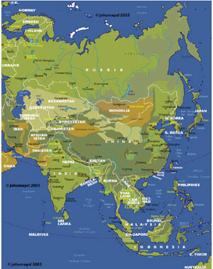
Map of Asia | ||
| Date: | Dec, 2010 (4rd Ed) | |||
| Map format: | jpeg | |||
| Dimension: | 810 x 1040 pixels (746 kb) | |||
| Copyright holder: | Johomaps! | |||
| Conditions of using this map: | Unlimited educational use, free download. Free web posting with web link to www.johomaps.com | |||
| Computer Specifics: | Prepared using Adobe Illustrator | |||
|
|
|
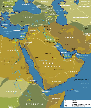
Map of the Middle East | ||
| Date: | July, 2005 | |||
| Map format: | jpeg | |||
| Dimension: | 661 x 788 pixels (217 kb) | |||
| Copyright holder: | Johomaps! | |||
| Conditions of using this map: | Unlimited educational use, free download. Free web posting with web link to www.johomaps.com | |||
| Computer Specifics: | Prepared using Adobe Illustrator | |||
|
|
|
Map of the Middle East (in Local Languages) | ||
| Date: | Oct, 2005 | |||
| Map format: | jpeg | |||
| Dimension: | 661 x 788 pixels (217 kb) | |||
| Copyright holder: | Johomaps! | |||
| Conditions of using this map: |
All rights reserved.
Contact |
|||
| Computer Specifics: | Prepared using Adobe Illustrator | |||
|
|
|
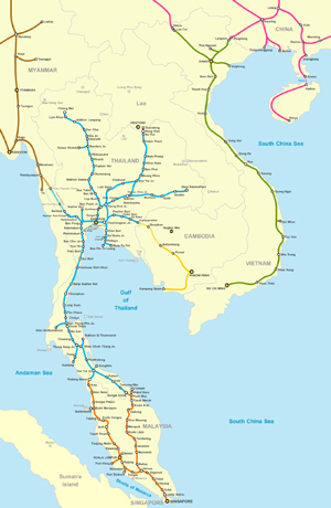
Rail Map of Southeast Asia | ||
| Date: | Oct, 2010 | |||
| Map format: | jpeg | |||
| Dimension: | 978 x 1500 pixels (481 kb) | |||
| Copyright holder: | Johomaps (Cartographer: Amnat Phuttamrong) | |||
| Conditions of using this map: |
All rights reserved.
Contact |
|||
|
|
|
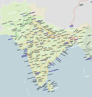
Rail Map of South Asia | ||
| Date: | Jan, 2011 | |||
| Map format: | jpeg | |||
| Dimension: | 1149 x 1218 pixels (258 kb) | |||
| Copyright holder: | Johomaps | |||
| Conditions of using this map: |
All rights reserved.
Contact |
|||
|
|
|
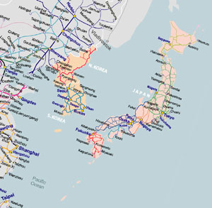
Rail Map of Korea and Japan | ||
| Date: | Jan, 2011 | |||
| Map format: | jpeg | |||
| Dimension: | 812 x 793 pixels (139 kb) | |||
| Copyright holder: | Johomaps | |||
| Conditions of using this map: |
All rights reserved.
Contact |
|||
|
|
|
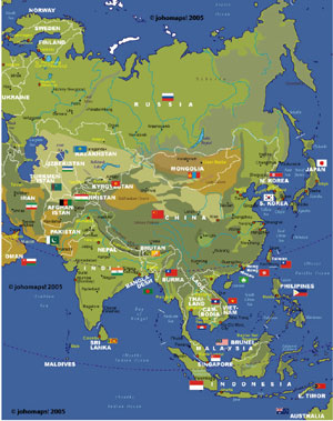
Map of Asian countries and flags | ||
| Date: | Jul, 2006 (3rd Ed) | |||
| Map format: | jpeg | |||
| Dimension: | 810 x 1040 pixels (406 kb) | |||
| Copyright holder: | Johomaps! | |||
| Conditions of using this map: | Unlimited educational use, free download. Free web posting with web link to www.johomaps.com | |||
| Computer Specifics: | Prepared using Adobe Illustrator | |||
|
|
|
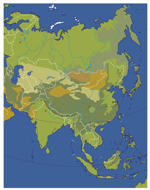
Blank Map of Asia | ||
| Date: | Dec, 2010 (3rd Ed) | |||
| Map format: | jpeg | |||
| Dimension: | 773 x 977 pixels (485 kb) | |||
| Copyright holder: | Johomaps! | |||
| Conditions of using this map: | Unlimited educational use, free download. Free web posting with web link to www.johomaps.com | |||
| Computer Specifics: | Prepared using Adobe Illustrator | |||
|
|
|
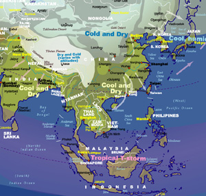
Weather Map of Asia (Winter) | ||
| Date: | Sep, 2006 | |||
| Map format: | jpeg | |||
| Dimension: | 668 x 637 pixels (214 kb) | |||
| Copyright holder: | Johomaps! | |||
| Conditions of using this map: | Unlimited educational use, free download. Free web posting with web link to www.johomaps.com | |||
| Computer Specifics: | Prepared using Adobe Illustrator | |||
|
|
|
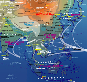
Weather Map of Asia (Summer) | ||
| Date: | Jul, 2006 | |||
| Map format: | jpeg | |||
| Dimension: | 668 x 637 pixels (214 kb) | |||
| Copyright holder: | Johomaps! | |||
| Conditions of using this map: | Unlimited educational use, free download. Free web posting with web link to www.johomaps.com | |||
| Computer Specifics: | Prepared using Adobe Illustrator | |||