開羅別名:
Al Qaira (阿拉伯語音譯), Masr
(本地人常用稱呼,但此字的意思是埃及)
Cairo
(From Wikipedia)
Copyright owned by wikipedia.org
See
here for copyright and licensing conditions
Cairo (Arabic: القاهرة
translit: al-Qāhirah), It comes from the arabic word "قاهرة" means "Triumphant", It is the capital city of Egypt (previously the United Arab Republic). It has a metropolitan area population of approximately 15.2 million people. Cairo is the seventeenth most populous metropolitan area in the world (the 10th according to 2004 statistics). Cairo is also the most populous metropolitan area and the most populous city in Africa. The city is located at 30°2' North, 31°13' East (30.03333, 31.21667). [1]
While al-Qāhirah is the official name of the city, in local speech it is typically called simply by the name of the country, Miṣr (Arabic, مصر) pronounced Maṣr in the local dialect.
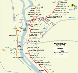
Cairo Geography
Cairo is located on the banks and islands of the Nile River in the north of Egypt, immediately south of the point where the river leaves its desert-bound valley and breaks into two branches into the low-lying Nile Delta region.
The oldest part of the city is somewhat east of the river. There, the city gradually spreads west, engulfing the agricultural lands next to the Nile. These western areas, built on the model of Paris by Ismail the Magnificent in the mid-19th century, are marked by wide boulevards, public gardens, and open spaces. The older eastern section of the city is very different: having grown up haphazardly over the centuries it is filled with small lanes and crowded tenements. While western Cairo is dominated by the government buildings and modern architecture, the eastern half is filled with hundreds of ancient mosques that act as landmarks.
Extensive water systems have also allowed the city to expand east into the desert. Bridges link the Nile islands of Gezira and Roda, where many government buildings are located and government officials live. Bridges also cross the Nile attaching the city to the suburbs of Giza and Imbabah (part of the Cairo conurbation).
West of Giza, in the desert, is part of the ancient necropolis of Memphis on the Giza plateau, with its three large pyramids, including the Great Pyramid of Giza Approximately 11 miles (18 km) to the south of modern Cairo is the site of the ancient Egyptian city of Memphis and adjoining necropolis of Saqqara. These cities were Cairo's ancient predecessors, when Cairo was still in this approximate geographical location.
[Read
full article]
|