|
新加坡 |
|
新加坡地圖 |
|
|
|
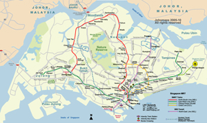
新加坡地鐵圖 (英語/馬來語) | ||
| 日期 | 2010年7月 (第3版) | |||
| 格式 | jpeg | |||
| 尺寸 | 1002 x 728 像素 (603 kb) | |||
| 版權擁有 | 卓號地圖 Johomaps! | |||
| 地圖使用之條件 |
版權持有人保留所有權利,有關本圖的使用權特許,請發電郵到  詢問
詢問
|
|||
| 更多資訊: | 使用 Adobe Illustrator 製作 | |||
|
|
|
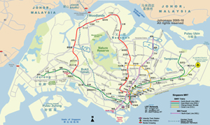
新加坡地鐵圖 (中文) | ||
| 日期 | 2010年7月 (第2版) | |||
| 格式 | jpeg | |||
| 尺寸 | 1002 x 728 像素 (603 kb) | |||
| 版權擁有 | 卓號地圖 Johomaps! | |||
| 地圖使用之條件 |
版權持有人保留所有權利,有關本圖的使用權特許,請發電郵到
詢問
|
|||
| 更多資訊: | 使用 Adobe Illustrator 和 Photoshop 製作 | |||
|
|
|
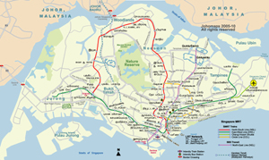
新加坡地鐵圖 (泰米爾語) | ||
| 日期 | 2010年7月 (第2版) | |||
| 格式 | jpeg | |||
| 尺寸 | 1002 x 728 像素 (603 kb) | |||
| 版權擁有 | 卓號地圖 Johomaps! | |||
| 地圖使用之條件 |
版權持有人保留所有權利,有關本圖的使用權特許,請發電郵到
詢問
|
|||
| 更多資訊: | 使用 Adobe Illustrator 和 Photoshop 製作 | |||
|
即時新加坡出行情報 |
|||
|
現時天氣 |
|||

|
資料 |
| 新加坡別名: Singapura (馬來語), 獅城 (非正式別名), 星加坡 (舊名,粵語對話仍然常用舊稱)
Singapore
(From Wikipedia) Singapore, formally the Republic of Singapore (Malay: Republik Singapura; Chinese: 新加坡共和国, Pinyin: Xīnjiāpō Gňnghégu?/i>; Tamil: சிங்கப்பூர் குடியரசு, Ciŋkappūr Kudiyarasu), is an island city-state and the smallest country in Southeast Asia. It is located on the southern tip of the Malay Peninsula, south of the Malaysian state of Johor, and north of the Indonesian Riau Islands. Its coordinates are , just 137 kilometres (85 mi) north of the Equator. |