|
土耳其 伊斯坦布爾 |
|
伊斯坦布爾地圖 |
|
|
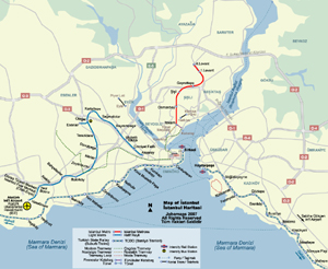
伊斯坦布爾地鐵圖 | |||
| 日期 | 2007年8月 | |||
| 格式 | jpeg | |||
| 尺寸 | 940 x 770 像素 (509 kb) | |||
| 版權擁有 | 卓號地圖 Johomaps! | |||
| 地圖使用之條件 |
版權持有人保留所有權利,有關本圖的使用權特許,請發電郵到 |
|||
| 更多資訊: | 使用 Adobe Illustrator 製作 | |||
|
即時伊斯坦布爾出行情報 |
||
|
現時天氣 |
||

|
City Info |
İstanbul (From Wikipedia) Istanbul (Turkish: İstanbul, Greek: Κωνσταντινούπολη, historically Byzantium and later Constantinople) is Turkey's most populous city, and its cultural and financial center. The city covers 25 districts of the Istanbul province. It is located at 41?N 29?E, on the Bosphorus strait, and encompasses the natural harbor known as the Golden Horn, in the northwest of the country. It extends both on the European (Thrace) and on the Asian (Anatolia) side of the Bosphorus, and is thereby the only metropolis in the world which is situated on two continents. In its long history, Istanbul (Constantinople) served as the capital city of the Roman Empire (330-395), the Byzantine Empire (395-1204 and 1261-1453), the Latin Empire (1204-1261), and the Ottoman Empire (1453-1922). The city was chosen as joint European Capital of Culture for 2010. The "Historic Areas of Istanbul" were added to the UNESCO World Heritage List in 1985. |
![]()
![]()