|
|
|
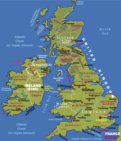
愛爾蘭及英國地貌圖 | ||
| 日期 | 2006年1月 (第2版) | |||
| 格式 | jpeg | |||
| 尺寸 | 489 x 515 像素 (183 kb) | |||
| 版權擁有 | 卓號地圖 Johomaps! | |||
| 地圖使用之條件 | 教育用途不受限制,免費下載. 提供網聯絡到www.johomaps.com可免費網上使用 | |||
| 更多資訊: | 使用 Adobe Illustrator 製作 | |||
|
|
||||
|
愛爾蘭及英國地圖 |
|
|
|
愛爾蘭及英國地貌圖 | ||
| 日期 | 2006年1月 (第2版) | |||
| 格式 | jpeg | |||
| 尺寸 | 489 x 515 像素 (183 kb) | |||
| 版權擁有 | 卓號地圖 Johomaps! | |||
| 地圖使用之條件 | 教育用途不受限制,免費下載. 提供網聯絡到www.johomaps.com可免費網上使用 | |||
| 更多資訊: | 使用 Adobe Illustrator 製作 | |||
|
|
||||
Web Maps (with Rating by Johomaps *)
| Rail
Map of Europe for Ireland and the UK
by Raileurope.com |
General
Rating: |
|
Click view map button
|
Required Program | No |
| Orthophoto | ||
| Road names and highway numbers | ||
| Additional Info | Major stations and railway routes, country by country | |
|
* Ratings are based solely on opinions of our map reviewers. Financial support and benefits to the web site have no influence on the ratings. |
![]()
![]()