卑詩省 (英屬哥倫比亞省)


請看: [溫哥華地圖]

卑詩省地圖

卑詩省海岸區原住民圖

放大本圖

Jonathan Ho 2003


Map of West Coast First Nations
  日期   2003
格式   jpeg
尺寸   800 x 778 像素 (96 kb)
版權擁有   Jonathan Ho
地圖使用之條件   教育用途不受限制,免費下載. 提供網聯絡到www.johomaps.com可免費網上使用
更多資訊:   使用 Adobe Illustrator 製作


溫哥華喬治亞海灣地圖

放大本圖

Jeff Burton, Kyle Gee, Julian Gonzalez, Jonathan Ho,
Alice Miro, Ervin Selak 2004


Map of the Straight of Georgia Basin (Relief)
  日期   2004
格式   jpeg
尺寸   598 x 585 像素 (160 kb)
版權擁有   Jeff Burton, Kyle Gee, Julian Gonzalez, Jonathan Ho, Alice Miro, Ervin Selak
地圖使用之條件   教育用途不受限制,免費下載. 提供網聯絡到www.johomaps.com可免費網上使用
更多資訊:   使用 ArcView 8.2 製作


南溫哥華島敏地圖

放大本圖

Jeff Burton, Kyle Gee, Julian Gonzalez, Jonathan Ho,
Alice Miro, Ervin Selak 2004


南溫哥華島敏感生態系統 (系列)
  日期   2004
格式   jpeg
尺寸   598 x 585 像素 (160 kb)
版權擁有   Jeff Burton, Kyle Gee, Julian Gonzalez, Jonathan Ho, Alice Miro, Ervin Selak
地圖使用之條件   版權持有人保留所有權利,有關本圖的使用權特許,請發電郵到 詢問
更多資訊:   使用 ArcView 8.2 製作


Interactive Maps (with Rating by Johomaps *) - External Links


Google Map General Rating:
  • High Definition satellite photo
  • User-friendliness: 4/5
  • Printer-friendliness: 4/5
  • Special Features: Hybrid Maps, i.e., highway info projected on satellite images.  Images are scaled and projections are very accurate
  • Good zoom in and zoom out function
  • Detailed info only appears at appropriate levels to avoid cluttering the map.
Required Program N/A
Orthophoto
Road Names and Highway Numbers
Additional Info Best Map search engine, but only works well in North America and selected cities in Europe.


British Columbia

Mapplace - Interactive Map of BC General Rating:
  • Cultural and Natural features are both mapped and integrated nicely onto the program with real consideration of the limitations of computer screens.  Themes are really well organized and easy to understand.  Many themes that are uncommon to be plotted on interactive media are also found there.  You can even choose how much details you need on your map for rivers and contour intervals.  Good separation of highly technical themes such as geophysical data into separate maps.  Annotation of features.  This site should be a 6 out of 5 if this rating is allowed.
  • User-friendliness: 4/5
  • Printer-friendliness: 4/5 (Useful copy button for copy and paste)
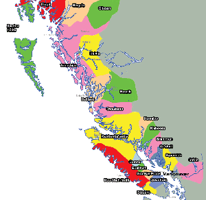
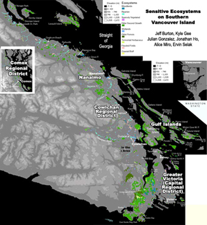
  • Special Features (Natural): Geological info such as faults, fault types, synclines / anticlines, rock unit contact, earthquakes, volcanoes and mineral occurrences, geographic 
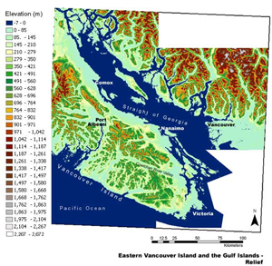
data such as Digital Elevation Model hillshade, bathymetry, detailed watershed info, detailed river info, contour map, glaciers, landsat photo, and even locations of waterfalls.
  • Special Features (Cultural):  Municipalities, electoral districts, regional districts, first nations reserves and treaties, railways, tree farms, landuse and planning, climate stations and even locations of wells!
Required Program Autodesk
Orthophoto  It's very fine.  Turn it on only when zoomed in very closely, not for urban areas
Road Names and Highway Numbers
Additional Info Many natural and cultural themes.  See description on the left


* Ratings are based solely on opinions of our map reviewers.  Financial support and benefits to the web site have no influence on the ratings.