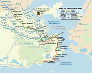
巴西. 里約熱內盧

本地新聞 | 天氣


里約熱內盧地圖

里約熱內盧地鐵圖

放大本圖

JohoMaps! 2006


里約熱內盧地鐵圖 
  日期   2010年11月 (第2版)
格式   jpeg
尺寸   699 x 555 像素 (132 kb)
版權擁有   卓號地圖 Johomaps!
地圖使用之條件   版權持有人保留所有權利,有關本圖的使用權特許,請發電郵到 詢問
更多資訊:   使用Adobe Illustrator 製作


即時里約熱內盧出行情報

現時天氣
巴西.里約熱內盧天氣預報 


兌換率


現在時間

資料

里約熱內盧 (From Wikipedia)
Copyright owned by wikipedia.org
See here for copyright and licensing conditions

Rio de Janeiro; Portuguese for River of January) is the name of both a state and a city in southeastern Brazil. The city was the capital of Brazil (1763-1960) and of the Portuguese Empire (1808-1821). Commonly known as just Rio (particularly in English and by its inhabitants), the city is also nicknamed A Cidade Maravilhosa - "The Marvelous City".

It is famous for its spectacular natural setting, its Carnival celebrations, samba and other music, hotel-lined tourist beaches, such as Copacabana, Ipanema, and Leblon, pavements decorated with black and cream swirl pattern mosaics, and the easygoing lifestyle of its inhabitants. Some of the most famous local landmarks in addition to the beaches include the giant statue of Jesus, known as Christ the Redeemer ('Cristo Redentor') atop Corcovado mountain; Sugarloaf mountain (Pão de Açúcar) with its cable car; the Sambódromo, a giant permanent parade stand used during Carnival; and Maracan?stadium, one of the world's largest. Rio also boasts the world's largest forest inside an urban area, called Floresta da Tijuca, or 'Tijuca Forest'.

Rio de Janeiro is located at 22 degrees, 54 minutes south latitude, 43 degrees 14 minutes west longitude (22?4′S 43?4′W). The population of the City of Rio de Janeiro is about 6,094,183[3] (2005 IBGE estimate), occupying an area of 1182.3 km?(456.5 mi?[4]. The larger metropolitan area population is estimated at 11-12 million. It is Brazil's second-largest city after São Paulo and was the country's capital until 1960, when Brasília took its place. Residents of the city are known as Cariocas.  The official song of Rio is "Cidade Maravilhosa."

[Read full article]


Interactive Maps (with Rating by Johomaps *) - External Links


Google Map General Rating:
  • High Definition satellite photo
  • User-friendliness: 4/5
  • Printer-friendliness: 4/5
  • Special Features: Hybrid Maps, i.e., highway info projected on satellite images.  Images are scaled and projections are very accurate
  • Good zoom in and zoom out function
  • Detailed info only appears at appropriate levels to avoid cluttering the map.
Required Program N/A
Orthophoto
Road Names and Highway Numbers


Reference Maps and Info  - External Links


Map and info of Rio's Subway and Light Rail System
Maps and the most updated info on the subway system of Rio.


* Ratings are based solely on opinions of our map reviewers.  Financial support and benefits to the web site have no influence on the ratings.