|
World > North America > Canada > Ontario > Toronto |
||
|
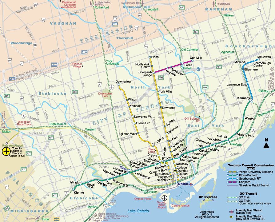
This map is integrated with Google Maps. Click on any stations (the circles) to see station vicinity maps |
||
|
|
||
|
|
||

|
Embed the most updated version of this map on your site. No permission needed.
|
|
Information (External Link) TTC
(Toronto Transit Commission)
The public transit network in the City of Toronto is an integrated network run by the TTC (Toronto Transit Commission). Transfers are issued at subway stations as well as by bus drivers so no extra fare is required in transferring between different modes of transport, which include all city buses, streetcars, all subway lines, and the Scarborough Rapid Transit (RT). Information Line: 614-393-INFO (614-393-4636) Nice List of Toronto subway maps by Robert Reynolds GO (Government of Ontario Transit)
GO Transit is a provincially run corporation. The double-decker GO trains are used mostly by commuters. Trains are only available during rush hours towards Downtown Toronto (Union Station) in the morning peak time, and away from Union Station in the afternoon peak time. Non-rush hour service is provided by GO buses between the stations. Some routes are served only by GO buses and are not shown on this map. The main corridor between Hamilton, Toronto and Oshawa is served by trains throughout the day in both directions. For more information call (416) 869-3200 or 1-(888) GET ON GO (438-6646) (External Link)Suburban Transit Some service is provided from Toronto to the suburbs, most are during peak hours only. Extra fare is required TTC bus Buses in the suburbs of Toronto are served by the different companies. To the east of Toronto by Ajax-Pickering Transit; to the north by York Regional Transit; to the northwest by Brampton Transit; to the west by Mississauga Transit Airport Ground Transport The GO Transit bus shelter is located at Terminal 2 on the Arrivals Level - post 20, and at Terminal 1 on the Ground level - column S2. The Westbound GO Busses takes passengers to central stops in Bramalea and Brampton. The Eastbound GO Busses take passengers to north Toronto including the Yorkdale and York Mills subway stations. [See
the airport map] (External Link)
|
![]()
![]()