|
|
|||
| World > North America > Canada > BC > Vancouver > Indian Arm | |||
|
[Back to Indian Arm Main Page]
Admiralty Point | Bedwell Bay |
Belcarra |
Best Point
| Bishop |
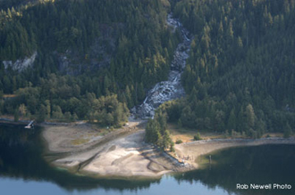
Granite Falls A spectacular place to camp. Distance from Deep Cove: 18 km Paddling Time One Way: Fast: 3 hrs. Avg: 4 hrs. Leisurely: 6 hrs. Suggested Route: Paddle the west shore to Croker Island, take the west channel between Croker and the Mainland, once you round the northern end of Croker you will see Granite Falls on the east shore. Hazards:
Features: Granite Falls is the best camping area on Indian Arm. Use the area south of the falls where there is a nice beach located. This is a BC Park with glamorous outhouse facilities. Camping first come first serve. Note:
We would like to enforce that there
are NO fires permitted at any campsite or on any island. |
||
| Photos and information courtesy of
Deep Cove Canoe and Kayak Centre |
|||