|
|
|||
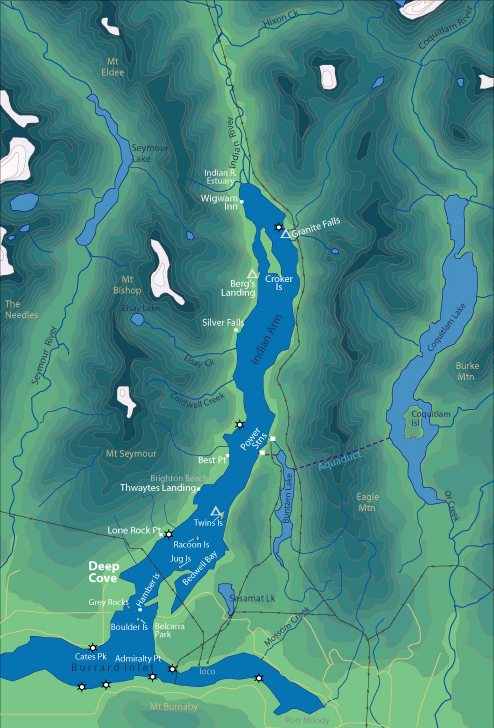
| World > North America > Canada > BC > Vancouver > Indian Arm | |||
|
[Back to Indian Arm Main Page]
Admiralty Point | Bedwell Bay |
Belcarra |
Best Point | Bishop |
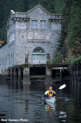
Power Stations There are two power stations that were built in the early 1900's. They are striking in appearance and stand out from a long distance. Somewhat gothic in construction, they would make great sets for a horror movie. Unfortunately there is no-where to land and the private property is owned by BC Hydro. Distance from Deep Cove: 10 km one way Paddling Time One Way: Fast: 1 hr. Avg: 1.5 hrs Leisurely: 2 hrs 15 min Suggested Route: Paddle the same route as to Raccoon Island, once at Raccoon diagonal north-east across to Twin Island. From here follow the eastern shoreline. Hazards:
Features: There are 2 power stations located here. They are very impressive structures, which would make great movie sets for a horror movie. The shoreline is very steep here with nowhere to land. History: These
building were constructed in the early 1900's. Water from Bunzten Lake was
initially used to turn the huge water wheels. A tunnel from Coquitlam Lake (5km
east) was completed in 1905. Workers were paid $3 - $5/day. |
||
| Photos and information courtesy of
Deep Cove Canoe and Kayak Centre |
|||