|
|
|||
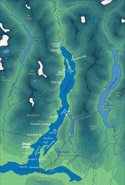
| World > North America > Canada > BC > Vancouver > Indian Arm | |||
|
[Back to Indian Arm Main Page]
Admiralty Point | Bedwell Bay |
Belcarra |
Best Point | Bishop |
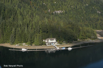
Wiggam Inn Wigwam Inn is a beautiful old hotel located at the northern end of Indian Arm with a long and notorious history. It is privately owned by the Royal Van Yacht Club and not open to the public. Distance from Deep Cove: 19 km Paddling Time One Way: Fast: 3 hrs Avg: 4 hrs Leisurely: 6 hrs Suggested Route: Paddle the west shore of Indian Arm. Hazards:
Features: This historic inn opened in 1910 as a world-class resort. It was operated by Count Gustav Constantin Alvo Van Alvensleben until 1963. It changed hands several times and was raided by RCMP as a gambling casino. Among its many guests were John D. Rockefeller and John Jacob-Astor. The Royal Vancouver Yacht Club currently owns the Wigwam Inn. Unfortunately you must be a member or know a member to do anything other than look. The building has a full industrial kitchen, shower and many nice hotel style suites. The view from the balconies is spectacular. History: You can locate four depressions in the ground on the middle of the island. A prospector who believed he could find blue diamonds on the island created these depressions. Nature: The
grounds have been landscaped with many rockwall and there are stands of
deciduous trees laden with moss. |
||
| Photos and information courtesy of
Deep Cove Canoe and Kayak Centre |
|||