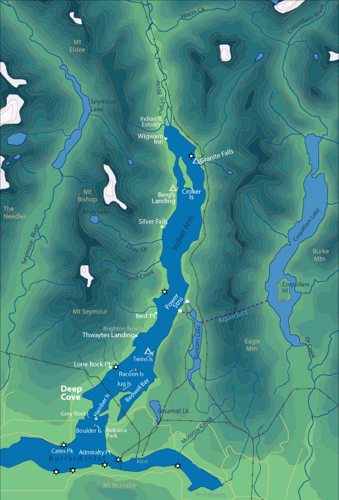
World > North America > Canada > BC > Vancouver > Indian Arm

Map of Indian Arm

[Back to Indian Arm Main Page]

Admiralty Point | Bedwell Bay | Belcarra | Best Point | Bishop
Bolder Island  |  Cates Park | Croker Island | Granite Falls | Grey Rocks | Jug Island
Indian River Estuary | Hamber Island | Lone Rock Point | Power Station
Silver Falls | Racoon Island | Thwaytes Landing | Twin Island | Wigwam Inn

Camping


Camping is on a first come first served basis. Reservations are not required or available. There are no fees for camping here. There are occasionally bear alerts at Bishop Creek and Granite Falls. All spots except Raccoon Island have out houses. Campfires are prohibited year round. For more information about BC Parks campsites on Indian Arm call (604) 929-4818.

Remember…If you pack it in... pack it out!

All the listed campsites are under the control of BC Parks, and we ask that all campers/paddlers respect and follow all park regulations.

Twin Island

Twin Island is the closest campsite to Deep Cove. There are several small sites on the southern island and one large site with several smaller ones on the bigger northern island. Twin Island is an easy 1.5-hour paddle from Deep Cove and is a great destination for you kid's 1st overnight adventure.


Berg's Landing

Bishop Creek / Berg's Landing is 3 - 4 hours of paddling. It is composed of an alluvial fan with flat areas to camp. Located at the south end of Croker Island, there is some good fishing here in the fall.


Granite Falls

Granite Falls is by far the best campsite on Indian Arm. Easy beach access with several sites nestled into a grove of trees; it is a great place to spend the weekend. From here you can check out the Indian River estuary, Wigwam Inn or just hang out. Granite Falls is very busy during August.


Photos and information courtesy of
Deep Cove Canoe and Kayak Centre

[See Metro Map of Vancouver] [See Vancouver Road Atlas]