|
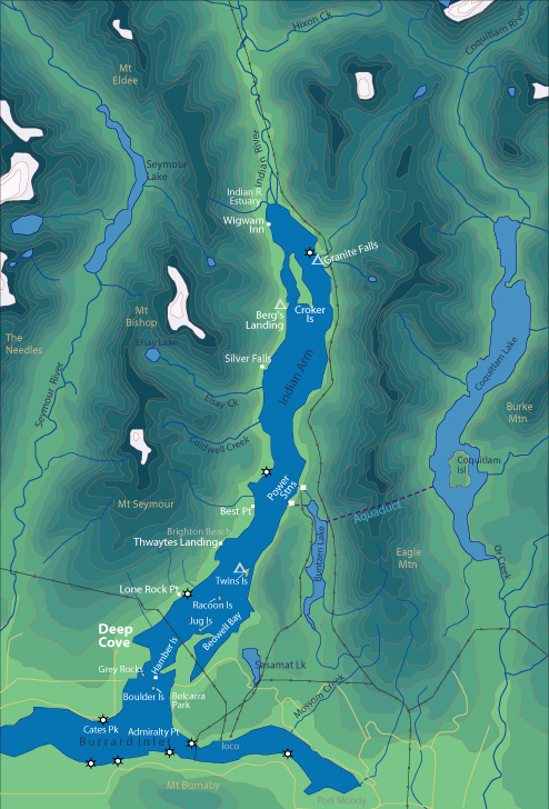
[Back to Indian Arm Main Page]
Admiralty Point | Bedwell Bay |
Belcarra |
Best Point | Bishop
Bolder Island | Cates
Park | Croker Island | Granite Falls
|
Grey Rocks | Jug Island
Indian River Estuary | Hamber
Island | Lone Rock Point | Power Station
Silver Falls | Racoon Island | Thwaytes
Landing | Twin Island | Wigwam Inn
|
|
Hazards
The waters of Indian Arm are for the most part
fairly calm, and relatively safe. Protected from ocean swells and storms, as
well as having little current, Indian Arm is a great place to learn how to
paddle. However if it were completely safe we would not need to write a section
on hazards. Remember that whenever you paddle in an ocean environment, weather
can be un-predictable, and can change quickly.
Know your limits
It seems that experienced paddlers exercise
more caution than rookies. Experienced paddlers through their own education, and
experience have become aware of the consequences of mistakes while on the water.
A good day of paddling in Indian Arm surrounded by spectacular scenery can very
quickly become a serious tragedy if you capsize. Nobody ever expects to capsize.
Water Temperature
Anytime you inadvertently end up in the water
hypothermia becomes a threat. The severity of hypothermia is determined by a
combination of the air and water temperature, your proximity to shore, your
ability to re-enter your boat, and your clothing. Water temperature in Indian
Arm is cold most of the year. It warms slightly in mid-summer. If you are
un-able to get to shore, or re-enter your kayak you are at serious risk. Bear in
mind that much of the shoreline of Indian Arm is very steep and difficult to
access. All kayakers should be familiar with capsize recovery techniques,
especially if you are planning full day outings or overnight trips.
Motor Boat Traffic
This
is probably the biggest hazard especially on weekends in July and August. During
certain times of the year it can feel as if you are the only person on Indian
Arm. On busy weekends crossing the channel can be a hair-raising experience.
- North Side of Deep Cove:
Deep Cove Marina is located here, hence many motor boats are coming and
going.
- Middle of Deep Cove: There are many
boats coming and going from Deep Cove Yacht Club and the Government Dock.
Enter and exit Deep Cove close to the shoreline.
- Mid-Channel of Indian Arm: Traffic is
busiest in the middle of the channel, paddle close to the shore.
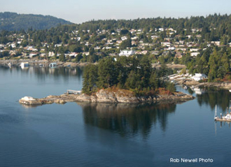
- Mid-Channel between Grey Rocks Island,
Hamber Island and Boulder Island: This area can be tricky as boats will
come from several different directions. Keep yours eyes open in all
directions, remember to use the one in the back of your head too! When
crossing the main channel stay in a group or pod. Cross quickly, do not
linger in the middle and do not cross in single file. Watch approaching
traffic carefully and try to predict their course. Make your actions as
predictable as possible.
Wind & Weather
The weather is most unpredictable during the winter from late October to April
and early May. This is not to say that un-expected squalls do not happen during
the summer.
Outflow winds:
During late fall, winter and early spring strong, cold outflow
(northerly) winds can whip down Indian Arm and create treacherous conditions.
During these winds there are not many sheltered areas.
Anabatic (inflow)
Winds:
These summer winds are very predictable on a sunny warm day. Typical to any
fjord or inlet an afternoon wind picks-up and blows from the south up Indian
Arm. These winds can surprise inexperienced paddlers who travel 1-hour north up
Indian Arm and find they have to paddle back into a head wind when they are
already tired. These winds also affect paddlers returning from overnight trips
to Granite Falls and Bishop
Creek.
Currents and Tides
The currents of Indian Arm are pretty mild. At most they will reach 1 knot. This
would have the effect of reducing your travelling speed, but most paddlers can
make headway against such a current. They would have greater effect combined
with a strong head wind at the end of a long days paddle. The area between Grey
Rocks Island and Hamber Island is the narrowest and shallowest part of Indian
Arm and consequently sees the greatest current. Burrard Inlet towards the Iron
Worker Memorial Bridge has extreme currents of 5 - 6 knots, with cross currents
from outflow of the Seymour River. Passing underneath this bridge you enter
Vancouver Harbour where non-motorized traffic is prohibited. This area is
extremely dangerous.
|